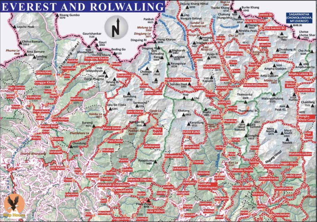
About Everest and Rolwaling
Nepal's most iconic high-mountain region, home to Everest and Sherpa heritage
Region Overview
The Everest and Rolwaling section of the Great Himalayan Trail encompasses some of the most iconic mountain landscapes on earth, home to Mount Everest (8,848 m), the highest peak in the world, and Mount Lhotse (8,516 m). Anchored by the UNESCO-listed Sagarmatha National Park in the Khumbu and the quieter, more rugged Rolwaling Valley further west, this is Nepal's best-known trekking region and offers an unparalleled combination of high-mountain scenery, glacial landscapes, and deep-rooted Sherpa culture.
Geography and Landscape
Sagarmatha National Park protects a dramatic high-altitude landscape of glaciers, icefalls, and moraines beneath Everest, Lhotse, Nuptse, and Ama Dablam, with trekking routes climbing through Namche Bazaar to Everest Base Camp, the turquoise Gokyo Lakes, and viewpoints such as Kala Patthar and Gokyo Ri. Several demanding high passes, including Kongma La (5,535 m), Cho La (5,420 m), and Renjo La (5,340 m), link the region's separate valleys. To the west, the more remote Rolwaling Valley offers rugged, glacier-carved terrain and the challenging Tashi Labsta Pass (5,760 m), while the park as a whole supports more than 1,000 plant species and over 118 recorded bird species adapted to high-altitude conditions.
Climate and Best Time to Trek
The clearest and most popular trekking windows are spring (March–May) and autumn (late September– November), when skies are generally stable and mountain views are at their best, though spring can bring more cloud build-up in the afternoons. Winter (December–February) is bitterly cold at altitude with heavy snow on the higher passes, but is still trekked for its crisp visibility on the lower Everest Base Camp route by well-prepared visitors. The summer monsoon (June–September) brings persistent cloud, rain, and obscured views, and is generally avoided except by dedicated flower and wildlife enthusiasts.
People and Culture
This is the heartland of Sherpa culture, expressed in villages, monasteries, and trails strung with prayer flags throughout the Khumbu and Rolwaling, with the Tamang, Thami, and Jirel communities also present, particularly toward Rolwaling. Historic monasteries such as Tengboche, Pangboche, Thame, and Lapchi, along with Bigu Nunnery, remain active centres of Buddhist practice and are frequently visited on trek, alongside spiritually significant sites such as Beyul Khandro. Trekkers can expect a well-developed teahouse network, seasonal festivals, and a strong local tourism economy built up over decades of mountaineering and trekking history.